In the late 1930s the government of President Lázaro Cardenas financed the completion of a paved highway from Mexico City to Guadalajara via Toluca, Morelia and Jiquilpan (Cardenas’s birthplace). To commemorate the first part, Mexico City to Morelia, author and art historian Pedro Ceuleneer de Gante was commissioned to write a short guidebook illustrated by maps and photographs for motorists using the improved route. Written in Spanish, this was published in 1939 as La Ruta de Occidente.
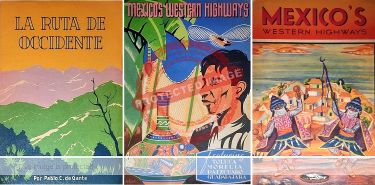
By 1940, the road (now federal Highway 15) had been completed all the way to Guadalajara, finally linking Mexico’s two largest cities by a ‘modern’ highway. The tourist potential of this route had long been recognized, since it included the southern shore of Lake Chapala. To celebrate the achievement, Mexico’s Western Highways, an English-language version of the book was released. Academic Kent Dickson’s assertion that this is a translation of La Ruta de Occidente is mistaken: Mexico’s Western Highways, “Presented by Pemex Travel Club” was an entirely rewritten guide, expanded to extend the route all the way to Guadalajara.
 The simple, but effective road maps in both Spanish and English versions were drawn by Pablo C de Gante, who also supplied some of the photos. Other photos are credited to POSTAMEX, Mauricio Yáñez, Ruperto Martínez, and ‘Chávez.’
At least two editions of Mexico’s Western Highways are known. They have identical interiors, but different covers and are printed on different grades of paper. The cover of the edition with thicker paper shows a man looking towards an earthenware bowl, with a traditional butterfly fishing net typical of Lake Pátzcuaro in the background. The front cover of the edition on thinner (cheaper) paper—a tourist edition with the logo and imprint of the Asociación Mexicana de Turismo (founded in 1939) on the back cover—shows Janitzio, the Lake Pátzcuaro island associated with Noche de Muertos (Night of the Dead).
Some idea of how difficult transport had been in this region prior to this highway’s completion can be gleaned from Leo Stanley’s account of riding horseback around the western end of the lake in 1937.
Equally, it is no coincidence that among the first high quality photographs of the south side of the lake are those taken by an American couple, Esther Henderson and Chuck Abbott, in about 1942 for the the Arizona Highways magazine.
Illustrations in the book relating to Lake Chapala include a view of the south shore; a photograph of a sail canoe, described as a “curious type of sailboat… popular among the native fishermen of Lake Chapala;” and a general shot of the resort town itself.
Chapala was where “the people from the city flock to enjoy the excellent swimming, to rest and recuperate. Many people of Guadalajara have built summer homes at Chapala; others go there for week-ends or simply to spend the day.”
The book paints an exaggeratedly idyllic picture of Chapala at the time:
The atmosphere of Chapala is essentially festive and gay. The town is very attractive with its white-walled houses, its beautiful gardens and promenades, the chalets which dot the water’s edge and the many palm trees which suggest the tropics. The air is always full of the music played and sung by strolling groups of mariachis. Good hotels and restaurants answer the practical needs of enjoying a stay in this delightful vacation place.
Swimming at Chapala is grand sport. The beaches are of fine clean sand, and the balmy climate induces one to spend hour upon hour alternately sunbathing and dipping into the water of this lovely mountain lake. Launches are available for making trips on the lake, including excursions to the islands known as Presidio and Alacranes.”
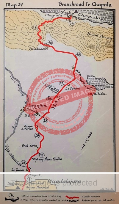
One interesting side note. The final map in the book (shown above) has a “Brick Works” midway between the side road to the Juanacatlán Falls (“The Niagara of Mexico”) and Guadalajara. Historically, there have been several brick works in that general area, including the one owned by English architect George Edward King at the start of the twentieth century. Among other buildings, King designed and built—using bricks from his own yard—Chapala’s iconic “Casa Braniff,” completed in 1905.
Several chapters of Western Mexico: A Traveler’s Treasury describe the fascinating villages and towns along Highway 15, which links Mexico City to Guadalajara and beyond.
Sources
- Kent L Dickson. 2013. “Una excursión por México en auto. Guías turísticas, 1925-1940.” 2013, Annual Juan Bruce-Novoa Mexican Studies Conference, UC Irvine.
- Pablo C. de Gante. 1939. La Ruta de Occidente. Mexico: D.A.P.P. (Departamento Autónomo de Prensa y Publicidad).
- Pablo C. de Gante. 1940. Mexico’s Western Highways. Mexico: Pemex Travel Club.
Comments, corrections and additional material are welcome, whether via the comments feature or email.
Tony Burton’s books include “Lake Chapala: A Postcard History” (2022), “Foreign Footprints in Ajijic” (2022), “If Walls Could Talk: Chapala’s historic buildings and their former occupants” (2020), (available in translation as “Si Las Paredes Hablaran”), “Mexican Kaleidoscope” (2016), and “Lake Chapala Through the Ages” (2008).